What was Abdul Haseeb's research about?
In Afghanistan, approximately 70 to 80 percent of all freshwater comes from snow-melt. Without that snow, rivers run dry, crops fail, and millions of people go without safe drinking water. Yet Afghanistan has almost no functioning stations to measure how much snow falls, how fast glaciers are shrinking, or how quickly groundwater is being pumped out of the ground. Decades of conflict destroyed much of the monitoring network — leaving decision-makers largely blind to an accelerating crisis.
For his doctoral research, Abdul Haseeb combined satellite observations, machine learning, and climate modelling to build the first comprehensive, country-wide picture of how Afghanistan’s water is changing across all five major river basins — covering the period from 1979 to 2024.
Main research findings
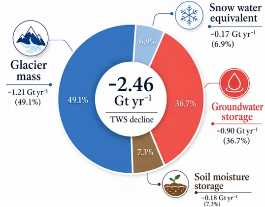
- Using gravity satellite data (e.g., GRACE) combined with machine learning to fill data gaps revealed that Afghanistan is losing water storage at a rate of 2.46 gigatons per year.
- The two main contributors are glacier retreat and groundwater depletion. Together, they account for 85.8% of Terrestrial Water Storage loss. In the Helmand Basin, groundwater alone is declining by over one gigaton per year, mainly due to intensive irrigation.
- Snow is disappearing quickly. Peak snowmelt now occurs about 35 days earlier than in the 1980s, and the total volume of snowmelt has fallen by about 25 percent. In the worst-affected basins, such as the Helmand basin, the decline is even steeper. Projections suggest that snowmelt could decrease by more than 70 percent by the end of this century under high-emissions scenarios.
- Snowmelt in Afghanistan is projected to decline substantially due to climate change. On average, a 1°C increase in temperature reduces annual snowmelt by about 11%. The greatest impacts are expected in the Helmand, Harirud-Murghab, and Northern basins, where snowmelt would reduce by 17-18%.
- The crisis is uneven. The Helmand and Harirud-Murghab basins are the most at risk and the most densely populated agricultural zones. Basins with the largest populations face the sharpest water losses.